- Nghiên cứu - Phát triển
- Hoạt động khoa học
Nghiên cứu ứng dụng kỹ thuật đồng vị đánh giá mối quan hệ thủy lực giữa dòng chảy sông Hồng và các tầng chứa nước không giới hạn chạy từ Sơn Tây đến Hưng Yên
Evaluation of the hydraulic relationship between the unconfined aquifers and the flow of the part of Red river running from Son Tay to Hung Yen is important to clean water safety and security for the daily life of local inhabitants living on thesidesof the river.It is said that this part of the riveris the major source of water for the aquifers during the rainy season of the year; on the contrary, groundwater seeps into the river, leading to an increase in river baseflow in the dry season. Currently, there have been several studies on the hydraulic connection between the Red river and Holocene and Pleistocene aquifers in Hanoi area using traditional hydrogeological techniques. Other advanced techniques, like isotope techniques, have not been applied for this topic. This encourages a team of researchers of the Institute for Nuclear Science and Technology to conduct a project entitled “Study on isotope technique application for the hydraulic relationship between Red river flow and unconfined aquifers from Son Tay to Hung Yen” with the aim of assessing the hydraulic interactions between the river flow and the unconfined aquifers through implementation of isotope techniques, contributing to cooperation activities between the International Atomic Energy Agency (IAEA) and Vietnam Atomic Energy Institute (VINATOM) in nuclear and related technique application for studies of environmental problems.
To get the project purpose, the team needs to build a methodological basis for the application of δ2H and d18O stable isotope techniques for water resource assessment, design sampling areas, and use suitable equipmentfor sample analysis. In this research, the samples were collected from the boreholes, which had typical hydrogeological properties of the study area in Holocene and Pleistocene aquifers, encoded Q9 and Q9a, Q67 and Q67a, Q129, Q129a and Q129b, respectively. Sampling activities were carried out twice per month in the duration of 12 months from August 2020 to July 2021. The samples of Red river water and rainwater were also collected from the hydrological stations in Son Tay, Long Bien, and Hung Yen at the same time as groundwater collection. The main analytical parameters included δ2H and d18O stable isotopes using LIWA-24D laser spectrometer, chemical components in water samples using DX-600 ion chromatography system, and field parametersusing SevenMulti pH/conductivity meter. Additionally, meteorological information such as temperature, humidity, precipitation, water level, water vapour, and discharge of the Red river was continuously collected from those stations.
From the sample analysis results, the group built a local meteorological water line and a local river water line, which enabled the group to determine the origin of groundwater, and assess the hydraulic relationship between surface water and groundwater through the separation process of the baseflow flowing into the river and mean transit time using isotope techniques. The results showed similarties to those of studies using other research methods by several authors, for example, Trieu Duc Huy (2021), Nguyen Minh Luan (2014), and Eckhardt (2005).
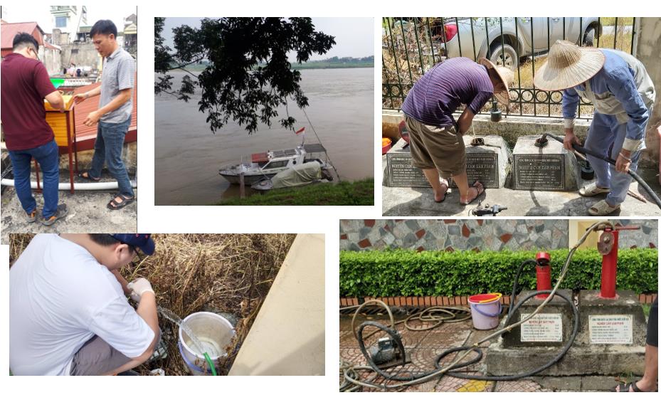
Photos: On-site sampling activities
The main results of the study were as follows:
+ The team set up a local meteorological water line d2H = (8.01 ± 0.14) x d18O + (12.65 ± 1.28), R2 = 0.98 and Red river water line d2H = (5.13 ± 0.25) x d18O – (13.03 ± 2.48), R2 = 0.86 (as shown in Figure 1).
+ It was estimated that the main river stream gained 38% of groundwater from the Holocene aquifer at Q9 in the rainy season and 25% in the dry season. For the Pleistocene aquifer at Q9a, groundwater seeped out into the gaining stream, accounting for 36% in both seasons. Meanwhile, at Long Bien site, the main stream recharged to both Holocene and Pleistocene aquifers at Q67 and Q67a at the rate of 89% and 70% in the rainy and dry seasons, respectively. At Hung Yen site, there existed a thick clay layer serving as an aquitard separating the Holocene aquifer from the Pleistocene and the Red river water. Thus, the river flow was not be able to interact with groundwater in the deep Pleistocene aquifer.
+ The mean transit time of the baseflow was estimated round 0.46 years at Vinh Tuong-Son Tay site, and 0.42 years at Hung Yen site.The water velocity of the baseflow was estimated to reach 10m/day and 7.2m/day at Vinh Tuong-Son Tay and Hung Yen sites, respectively.
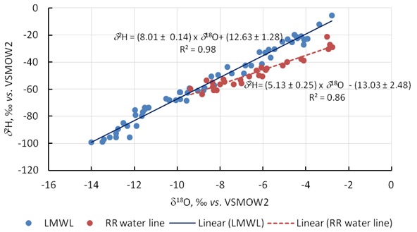
Figure 1. Local meteorological water line (LMWL) and Red river (RR) water line
Finally, based on the investigation of the field values, chemical components, and stable isotope values on the samples of Red river water and rainwater collected from the hydrological stations in Son Tay, Long Bien and Hung Yen, and from the seven boreholes, the team was able to evaluate the hydraulic relationship between the Red river flow and the boreholes in the unconfined aquifers. The research results have been presented in two research papers published in international scientific journals, two papers in domestic journals, two reports at the national scientific conferences. This project has also supported a young researcher in earning a master of science degree.
Institute for Nuclear Science and Technology


.png)